


اسئلة الماب من انواع الرسوم اللي تحس انها صعبة ومعقدة لكن العكس هو الواقع..لانه يكون فيها تفاصيل كثير فسهل عليك تعبي الـ ١٥٠ كلمة
ممكن يجي خريطتين في الماضي والحاضر او خريطة واحدة في الماضي ويجيبها ليك قبل ،بعد التغييرات اللي صارت فيها.. وهذي بعض الأمثلة على شكل سؤال الخرائط
اتفقنا راح نستخدم القالب “اهم تكنيكة في الكتابة” لحل هذا النوع من الرسوم..
ودحين خليني اوريك مثالين من مشاركتكم تم حلهم باستخدام القالب 🤸🏻♀️
المثال 1️⃣
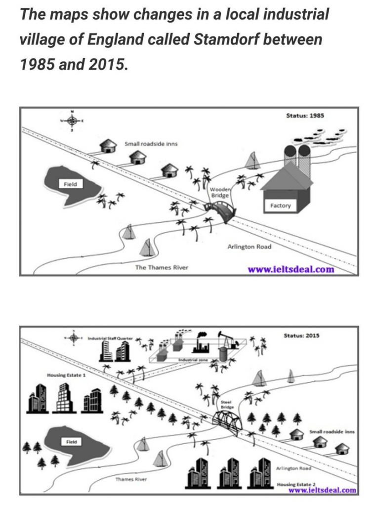
The development which occurred in the village of Stamdorf is illustrated in these maps below over 30 years. It is clear from the graph that the Village had became more modernized and the village’s appearance had changed completely during the period.
According to what shown, the eastern part of the Arlington road had developed entirely. The old wooden bridge was redeveloped into a modern Steel one. Near the bridge, the factory was flattened and new trees were planted instead. Moving to the north of the river, small roadside inns were relocated to the south of the Thames river, while a new extension of the main road was built leading to a new large industrial area. Just over the extension, an industrial staff quarter was erected.
On the other hand, the western district of the main road witnessed big changes. Starting from newly constructed housing estates, which situated on the northern and southern part of the Thames river. The Field opposing the Arlington road in 1985 was relocated southerly adjacent to the river.
To sum up, we could say that although many changes took place in the village, the village’s planning remained almost the same during the two years.
إذا حاب تشوف التصحيح كامل مع تعليق المصحح على الأخطاء اضغط هنا
المثال 2️⃣

This map depicts two possible locations to construct a new supermarket in Garsdon town. It is clear from the map that,the town has three main roads andthe railway.
According to what is shown, the first possible site for the supermarket is located in the north-west countryside which is adjacent to the industrialarea and near the northern housing area. It serves about 75,000 people in both Garsdon and Hindon town, which lies 12 km away from Garlsdon town.
The other possible site is situated exactly in the center of the town. This location is between two housings areas and two main roads that leads to two different towns, which are Cransdonhas population29000 and Brandsonhas 15000.
To sum up, we could say that both sites are nearest to the train, however; the first one served two towns while the S2 is served three towns.
إذا حاب تشوف التصحيح كامل مع تعليق المصحح على الاخطاء اضغط هنا
إذا استفدت شارك هذا المقال 💛
وإذا عندك اي سؤال ارسلي في تويتر من هنا


0 تعليق